



VRTool

VRTool介绍
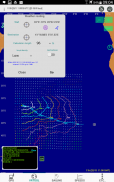
VRTool "SideKick" (VSK) integrates charting, sailing calculator and GPS data logger. It transforms your GPS enabled phone or tablet in a powerful sail boat racing tool.
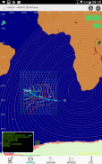
Now it brings most of VRTool desktop charting features, packed in this mobile app. Key data components used by VSK in charts and calculations include:
- GPS position ( or you can type coordinates )
- GSHHS world maps
- Polar chart for your boat ( customized ).
- NOAA GFS wind forecasts.
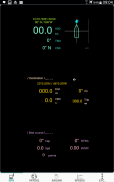
VSK shows the current polar line, TWA, sail efficiency, best course to destination, great circle distance and course. Also operates as a data logger, saving boat positions and other sailing variables periodically.
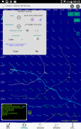
Charting tools include: measure tool, route and track design, add mark, add geodesic circles. Weather routing calculation up to 144h, with hi-res collision detection.
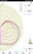
Real time editor for your customized boat polars. Edit polars as you sail by dragging the curve points.
Sidekick can also be configured to act as a NMEA talker, broadcasting GPS messages to other software connected to the boat TCP/IP network via boat wi-fi.
VRTool “的SideKick”(VSK)集成图表,帆船计算器和GPS数据记录器。它会将您的GPS功能的手机或平板电脑在功能强大的帆竞渡的工具。
现在,它带来的大部分VRTool桌面图表功能,装在这个移动应用程序。在图表和计算使用VSK关键数据的组件包括:
- GPS位置(或者你可以输入坐标)
- GSHHS世界地图
- 你的船(定制)极坐标图。
- 诺阿GFS风的预报。
VSK显示当前极线,TWA,航行效率,目的地,大圆距离,当然最好的办法。也作为数据记录器,节省了船位置和其他帆船变量定期。
制图工具包括:测量工具,路线和轨道设计,添加标记,加测地圈。天气路由计算达144小时,与高分辨率的碰撞检测。
为您量身定制的船极性物质实时编辑。编辑极性物质如您通过拖动曲线点起航。
搭档还可以被配置为充当NMEA讲话者,广播GPS消息经由船的Wi-Fi连接至船TCP / IP网络的其他软件。


